It would be greatly appreciated if you can lend a few hours of your time to help clean up that area and we may spread out and see what other dump sites have sprung up over the winter.
Okanagan Forest Task Force has a self loading truck and a bin for all the RV steel but with people being people there probably is other junk out there… and who knows what the party spot/shooting gallery under the powerlines looks like!
What to Bring:
your ATV if you want to ride around looking for trash (and do a little riding after?)
your car/truck if you’re just coming to the main mess at 2km
gloves, good boots, dirty clothes
something to clean up with after
Signing the Waiver – because this is a club organized event, all participants will be required to sign the waiver saying you won’t sue the organizers or the club if you are injured at the event. If you’d like to sign the waiver ahead of time please visit the ATVBC website and bring a copy of the email or a screenshot on your phone Saturday.
I was frustrated when I first heard about the new waiver requirements imposed on ATVBC by its insurance company and what it would mean for rides and events. It concerns me that our legal system rewards someone injured while willingly participating in a club event instead of holding them accountable for their actions and decisions. Given a few minutes to reflect, I put myself in the shoes of someone injured who loses the ability to make a living for months or years and came to understand why they might try using the legal system to keep themselves and their family afloat at the expense of volunteers and their organizations.
I don’t have the power to change the legal system so I accepted that we would need to comply with the new waiver requirements so our club could continue to function without risking the financial future of all our volunteers. Our volunteer directors, ride leaders, tail gunners and everyone who has ever been in a decision making role in the club have spent too much time, energy and money sharing the love of ATVing with others to be sued for everything they own.
Why Waivers? Signing the waiver means you’re waiving your right to sue the club, directors, ride leaders, etc. Please read the waiver on the ATVBC website and be sure you understand what it means for your legal rights should you be injured at a club event.
As of May 1, 2022 all new and renewing memberships can only be purchased via the ATVBC website. When you complete the membership form you are required to accept the waiver.
As of May 1, 2022, all people participating in club rides and events will be required to have signed the waiver. The recommendation from ATVBC (its insurance company) is that we have everyone sign a waiver at every event to ensure we don’t miss anyone. The club is still determining if it will track who has a current waiver or if we’ll use the waivers for everyone approach.
Non-members and guest riders are still welcome on rides provided they read, understand and sign the waiver.
What Does This Mean For You? You either sign the waiver and can participate in club rides and events, or you don’t sign and you can’t.
Effective May 1st, ATVBC will be converting to on-line transactions for the purchase of new or renewal club memberships. This will mean the end of the paper transactions that we had been used to. Over the past few years, the majority of Vernon club members have already made this switch and have been using the ATVBC website to purchase their club memberships.
It’s long overdue to give a big shout-out to the staff at Johnston Meier’s Vernon office for their service in handling the paper renewals at their office for these many years. Please be aware that you will no longer be able to purchase your ATVBC membership at their office as of April 30th. You will need to bring your ATVBC membership information with you when you go to get your insurance. Please be kind and respect the Johnston Meier staff if they politely inform you that you have to bring your membership paperwork with you.
For those members who are renewing, you should have received a reminder email from ATVBC where you can click on the URL in the invoice to lead you through the process. Otherwise you can go to the website www.atvbc.ca and click on the Join ATVBC link to take you to the renewal.
Once your purchase is complete, you will get an email from ATVBC with your membership details and a membership card you can print out if needed. You will need to take this info with you when go to renew your machine’s insurance policy in order to get the club discount. In a hurry? You can screenshot or print your membership card while you are still on-line after making your purchase and take that to your insurance agent.
Your membership is valid for 1 year and you will receive a renewal reminder via email prior to the expiry date. As always, please ensure that you advise ATVBC of any changes to your email address so that they can keep you up to date.
We haven’t had a wheeled group ride for far too long and the chatter on Vernon ATV Trail Riders suggests the Noble Canyon trails are in good condition for wheeled ATVs.
Meet at the cattleguard on Noble Canyon Road in Lavington at 1:00pm for the safety meeting then it’s off to explore all the trails we can find, we’ll aim to be done riding and back down between 5-6:00pm.
Remember you can’t unload before the cattleguard, either unload at the cattleguard then park along the road back toward the highway or continue up Noble Canyon Road past the cattleguard to find parking along the roadside. Please don’t park in the turn around, trailers use this to turn around and don’t block any driveways (simple stuff right?).
This will be an intermediate level difficulty ride due to the winter conditions and with the mild temperatures it’s possible the roads will be extremely slick in spots. A single tank of fuel will be sufficient, bring your extraction gear and emergency kit. We should pass a recreation site with an outhouse at some point during the ride.
Vernon ATV Club rides are open to everyone. Attend a few rides to meet other riders, find new trails and see that ATV Club membership has its benefits!
It was a beautiful warm and sunny day for the 2022 Vernon Winter Carnival Parade with enthusiastic spectators lining the parade route. For 2022 the Vernon ATV Club and Vernon Snowmobile Association teamed up to enter the largest parade entry, check out the videos to see all the action.
Once a year we have the chance to ride the streets of Downtown Vernon in front of thousands of eager onlookers.
The Vernon Winter Carnival Parade is 61 years strong and is a really fun event. Children and families line the streets to see the floats roll by and love seeing quads and side x sides.
Carnival normally has a theme but this year there isn’t so it’s an easy one because you don’t need to decorate your machine. All you need to do is show up by 11:00am on Saturday, February 5 with your machine to take part in the fun.
Check out past Vernon ATV Club Winter Carnival Parade entries and sign up by Sunday, January 23 using the form below or by emailing info@vernonatvclub.ca.
We’re looking to get as many machines out as possible, 10 would be good, 20 would be better and 50 would be beyond awesome!
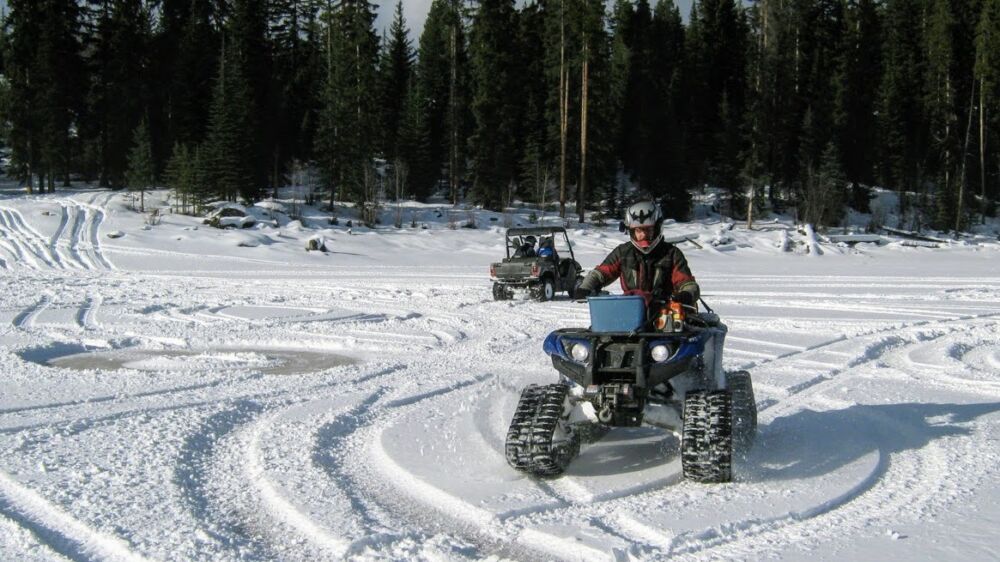
It’s the time of year where the snow is piling up enough to make a ride with wheeled ATVs a frustrating day of pushing, pulling and digging. There are a few rowdy souls out there with tall tires and heaps of horsepower who continue on wheels in these conditions but most folks who want to continue ATVing through winter may start thinking about tracks.
ATV snow tracks aren’t cheap and they aren’t for everyone so I thought I’d share my experience from years of snow track ownership.
Our first set of ATV tracks were TJD Cat Tracks, a Quebec made track advertised as year round tracks for snow, swamp, mud, etc. The track design used a combination of bogie wheels which allows for all season use and a slider strip (like snowmobiles use) for the winter operations. TJD sold their track division to Camoplast which is now Camso, the market leader for powersport track products.
This first set of tracks were installed on a 2006 Yamaha Kodiak 400 which meant you weren’t going anywhere fast but you could go almost anywhere. There was no power steering back then so if you got on an off-camber you had to fight it hard to keep the machine from going downhill. These tracks worked so well for winter forestry work we bought a second set, this time mounted to a 2007 Kawasaki Brute Force 750.
Both track kits are still around today, by purchasing a different fit kit we’ve adapted the Brute Force tracks to a Yamaha Grizzly 700 and the Kodiak tracks fit straight onto a Yamaha Rhino side x side.
How do ATV tracks work? ATV tracks bolt onto the lug nuts to drive the tracks through an oversized cog, the track assembly is held in place with a fit kit or set of brackets that secure the track assembly to your ATV’s suspension.
Gearing for different displacement machines is achieved by using a different size drive cog. As you go up in engine size the number of teeth on the drive cog goes down. That’s how the same track assembly can be made to work on a 400cc machine (17 tooth) and a 700cc machine (15 tooth).
How much fuel will you use? A lot! Those large drive cogs give your ATV mechanical advantage over the tracks but it comes at a cost of lower top speeds and increased fuel consumption. Plan on using twice as much fuel, this varies though depending on snow depth, snow type, slope of the trail and how far you like to push the pedal.
How long does it take to install them? The first time you install them it’s going to take hours but once you’re familiar with the process and learn to align the lug nuts to the drive wheels and cinch those up then the fit kits bolt up fairly quickly. Then you check your limiting bolt adjustment and track tension and you’re off.
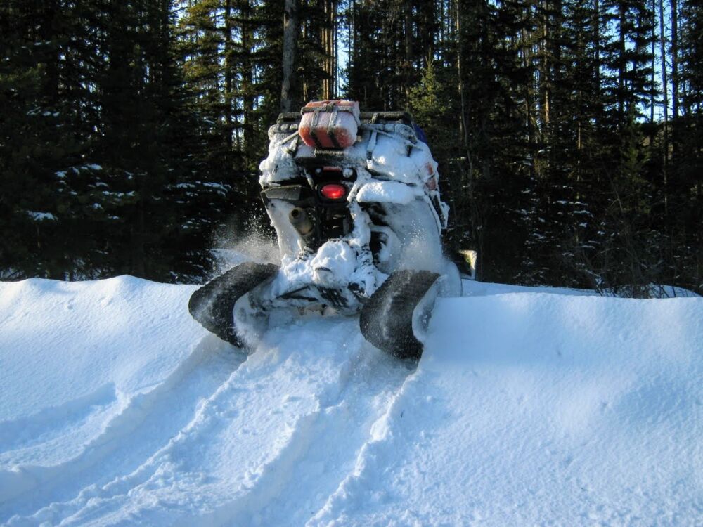
Where can you go? ATV tracks will go almost anywhere and keep your machine on top of the snow. When you get off your machine you’ll need to be careful you don’t end up knee, belly or deeper in the powder your machine is effortless riding atop.
Steep slopes and certain types of snow will stop tracked machines but otherwise they go almost anywhere.
When do they suck? Hard packed and icy trails are no fun. When you put tracks on your machine you’re getting rid of all the suspension your tires provide. Most track systems recommend you crank up your shock preload/stiffness to prevent the track assembly from hitting your machine’s bodywork so frozen bumpy roads and hard packed trails will send jolts through the tracks directly to you.
You also need to be prepared to become the abominable snowman. If you’re not going perfectly straight the tracks are kicking up a huge amount of snow. When riding a quad this packs around your legs and feet in the footwells and in a side x side snow gets everywhere inside the cab if you’re not fully enclosed.
When are they awesome? As soon as you have a couple of feet of snow the ride smooths out and you can go off the beaten trail.
Background on this video: Steve was stuck on his quad so Marc hooked up to tow him to safety but instead takes him on a minute long tour of untouched powder then returns Steve to the exact spot where he first hooked up to him. Unfortunately we missed the minute tour of the powder, we were all laughing and all Steve could do is follow along.
Is it hard on the machine? I haven’t noticed any damage from regular use of the tracks. The tracks are large with a lot of leverage so if you tag a hidden log or rock it’s possible you’re going to bend or break something in your suspension.
The biggest problem we encountered is needing to clean out around the suspension and driveshafts or else everything could ice up and possibly tear a CV boot with all the snow/ice packed around the drivetrain.
You’ll also want to check your oil and coolant before each ride because you’re often riding at higher RPMs for sustained periods, like when climbing for a protracted time.
What do they cost? For a quad you’re looking at around $4200 for Camso T4S and for a side x side it’s $5600ish for the Camso 4S1 (both previously called Camoplast Tatou Tracks).
It’s definitely worth keeping an eye on the classifieds because good looking used track kits come up in the $2-3000 range.
The good part of tracks is you’re probably not going to get stuck, the bad part is you spend the day towing other people.
Your homework? If you’re thinking about tracks you want to do a bunch of research and talk to as many people who own tracks as possible because everyone has a different opinion to share.
Ride Recap We couldn’t have asked for a better day with perfect blue skies and smiling faces.
19 machines and 25 riders did the morning tour that started from 2km on Noble Canyon Road and wandered over toward Dixon Dam then back along the western road before stopping to take in the amazing view over the Coldstream valley and City of Vernon.
Next stop was lunch at The Ponds recreation site followed by the fashion show, awarding of prizes then a quick ride back down to 2km.
Ride Leader Steve was back for his first ride in several months, he took the riders looking for a bit more adventure on one of his favourite rides to Cactus Ridge where the group debated just sitting and enjoying the view and sun for a few hours.
After a few minutes riders were restless again so the group headed east to complete the loop around Bardolph Lake and home.
9:30am start Sunday October 31 @ Noble Canyon Road
It’s a ride, a halloween costume contest and a GPS challenge to find the hidden candy all in one! Come as you are or come in costume, it will be a fun day on the mountain.
Please email info@vernonatvclub.ca by 5:00pm Saturday if you’re coming so we have enough food for everyone.
Starting a bit earlier with the 9:30am safety meeting followed by the costume catwalk then off on a ride to a secret location where you use your GPS to find the hidden candies.
Come back from your candy hunt for a BBQ lunch then we head back down and home with plenty of time to get ready for trick or treating with the kiddies.
Prizes for those participating in the costume contest and the GPS candy hunt.
From Vernon: 12.5km east from Aberdeen Road to Noble Canyon Road on Highway 6 Entering Lavington there is a PetroCanada station on the right, it’s 2.5kms from here to turning left onto Noble Canyon Road. We’re staging at 2km up Noble Canyon Road, just after crossing the bridge find a parking spot along the road.
There are outhouse facilities at the Ponds Recreation site where we’ll be stopping for lunch.
Trails are beginner to intermediate difficulty, if you’re a newer ride please talk to us before the ride so we can plan accordingly and pair you up with more experienced riders. Speeds may reach up to 60kmh on the Forest Service Road sections.
A single tank of fuel will be sufficient for the entire day.
Vernon ATV Club events are open to everyone, invite your friends and enjoy a fun day on the trails!
The forecast said the rain would ease off in the afternoon but the rain persisted through the night. That didn’t stop 10 machines and 15 riders from donning their wet weather gear to hit the trails.
Wet and dark so just this staging area photo!
Thanks to ride leader Allen for co-piloting in the side x side while his arm is healing, Allen knows the Mt Ida trails better than anyone which made for an awesome mix of FSR and tight and twisty trail.
From the Deep Creek Road staging the ride headed south on the FSR in challenging misty conditions with foggy goggles before ducking off on a newer cut block road which joins onto the trail to Silver Creek. A short break at Silver Creek then back on the trails past the lake, down the powerlines then back on the FSR to staging.
We discussed navigation tools and I promised to share the trail and discount links for GaiaGPS:
Starting from the Deep Creek Road staging area at Mt Ida, the goal of this ride is to hit the trails to enjoy the recent full moon (Wednesday), take in the amazing views of the city of Salmon Arm and tell stories around the campfire.
The forecast currently is calling for rain Friday night so come prepared for all conditions.
Night riding adds an element of difficulty so you need to be sure your lights are working and be confident in your abilities to tackle this ride. The trails aren’t that difficult but things sneak up on you in the dark.
There are a couple of outhouse facilities at Mt Ida, we’re not sure if we’ll be passing them so come equipped to do your business in the bushes.
The ride will be 2-4 hours and a single tank of fuel will be sufficient.
Two fun rides on the Thanksgiving long weekend. The Saturday ride visiting the Trinity Ricardo trail network north of Silver Star Provincial Park. After slogging through a tight trail tangled with blowdown and alder, the ride stopped at the Vernon Snowmobile Association Armstrong Cabin for lunch. After lunch the ride continued to the park boundary then back along the snowmobile trails to the Slide Trail with the ginormous rock overhanging the trail (check Vernon ATV Trail Riders group for photos).
The Monday ride’s mission was to summit Terrace Mountain then wander the area trails. After riding through increasingly larger road deactivations the group finally was at the base of Terrace Mountain, a quick squirt up the switchbacks took the group to the top for a spectacular 360 degree view. Fortunately the sun poked through a few times and the wind stayed down enough to remain atop Terrace Mountain to enjoy the view before descending to continue the ride to explore area FSR and old logging roads.
10:00am Start Saturday for Trinity Ricardo Ride
Trinity Ricardo is a trail network to the north of Silver Star Provincial Park accessed from Trinity Road in the summer and used as snowmobile trails from within the park in the winter.
A convoy will be leaving the Tim Hortons on 58th Avenue across from Walmart Vernon at 8:30am, the next stop is the Enderby Chamber of Commerce at 700 Railway Street. Leaving the Enderby Chamber of Commerce at 9:15am for the gravel pit staging area on Durnin Road. The preride safety meeting will start at 10:00am. Map to meeting locations and staging.
Trinity Ricard reaches 1800m elevation so we may encounter cold, wet and even snowy conditions so come prepared for all conditions.
A single tank of fuel will be more than enough for this ride, trail difficulty will range from beginner to intermediate with speeds reaching up to 50kmh on FSR.
We will be stopping at the Vernon Snowmobile Association Armstrong cabin that has an outhouse.
Pack a lunch, this will be a leisurely ride with a few stops and opportunities to enjoy the views along the way. The ride should be wrapped up by 4:00pm.
10:00am Start Monday for Westside Road Ride
NOTE: Thank you to the BC Wildfire service for discussing our request to access the Whiterock Lake fire closure area. Our request has been declined so we are moving this ride a little further south to Terrace Mountain which is outside the fire closure area.
Our usual convoy leaves the Tim Horton’son 58th Avenue across from Walmart Vernon at 8:30am for Terrace Mountain Road on the Westside. We will wait at the bottom of Terrace Mountain Road (just past the LaCasa Resort development) until 9:15am then will drive up until we find a suitable area to park and unload safely along the road, the preride safety meeting starts at 10:00am. Map of meeting location to Terrace Mountain Road.
Ride speed with reach up to 50kmh on Forest Service Roads, ride difficulty will be beginner to intermediate with assistance should we encounter difficult obstacles. We may pass recreation sites with outhouse facilities so plan accordingly.
Come prepared for all weather, bring a lunch and your camera as there are lots of vantages and viewpoints along the ride.
Bring extra fuel as we’d like to explore a loop so we’re not riding the same roads/trails on the way out and back. The plan is to be back at the staging area by 5:00pm.