Jim is really enjoying his new Polaris Ace so has offered to lead a ride to Pinaus Lake and Tuktakamin Mountain Sunday morning. The ride starts early to beat the heat and you should bring a jacket because the Tuktakamin Mountain summit is at 1775m (5825 feet) elevation so it may be cool at the top.
The forestry fire lookout that lived atop Tuktakamin Mountain from the 1950s to 2005 now resides at the Falkland Museum & Heritage Park on the left as you enter Falkland heading west toward Kamloops. Lookouts were always placed to provide a commanding view of as much terrain as possible so the view from the top is amazing.
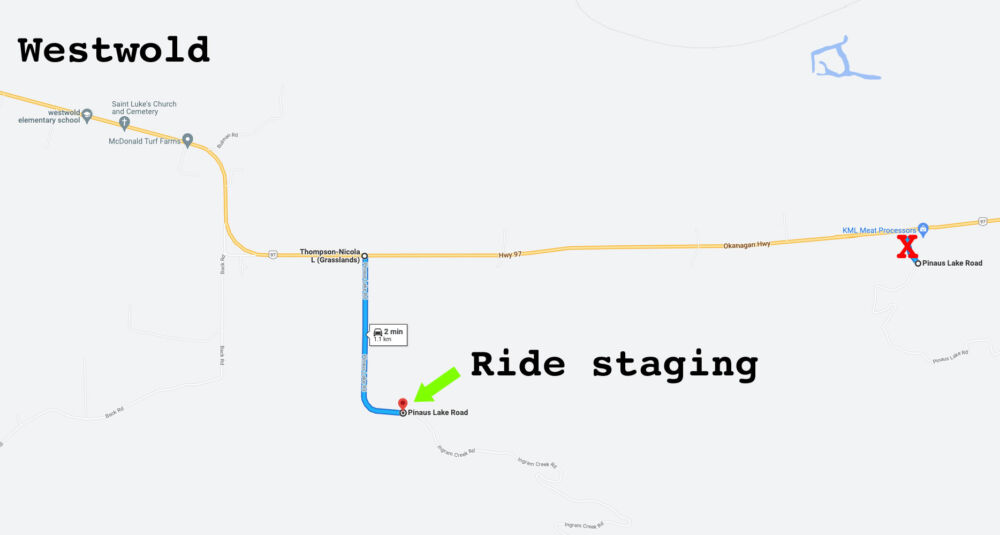
Ride Staging Area See the images below for directions to the staging area. Google Maps calls it Pinaus Lake Road but the FSR is named Ingram Creek Rd. Drive 1km up this FSR to where you find a wide area to park.
DO NOT PARK AT THE KML MEAT PROCESSING PLANT ROAD which is also called Pinaus Lake Road – this is not the staging area.
This is what the turnoff looks like as you are heading west toward Westwold.
Connecting Vernon, Beaverdell, Renata, Edgewood and other communities
Inspired by the success of the North Island 1000 that visits multiple communities on northern Vancouver Island, we wanted to explore the concept of a multiday offroad route that incorporates smaller communities that are open to ATVs accessing fuel and amenities.
A handful of machines left King Eddy at 8:00am on Canada Day on the first leg of the journey on familiar trails regularly used for club rides. Once past Ideal Lake the ride ventured onto trails only used by the club on the Epic 250km ride a couple of years ago, then the route turned onto Okanagan Falls/201 FSR where it was all new terrain. There are two legal road crossings (with stop signs on either side of the pavement) for Big White Road and Highway 33.
We arrived at Beaverdell 4 hours after leaving King Eddy but made the mistake of trying to access Beaverdell along the KVR from the south and encountered a boulder placed at a bridge blocking ATV access (locals informed us to come in on the KVR from the north to get into town). Each machine was packing extra fuel (40L for side x sides, 20L for quads) so we skipped the planned Beaverdell fuel and food/grocery stop and continued south where we encountered the third legal crossing back over Highway 33 to start heading east.
The temperature was climbing and all the roads were freshly graded so Taurus (Bull) Lake Recreation Site provided a welcome break from the heat and dust and an opportunity to meet locals fishing for the day.
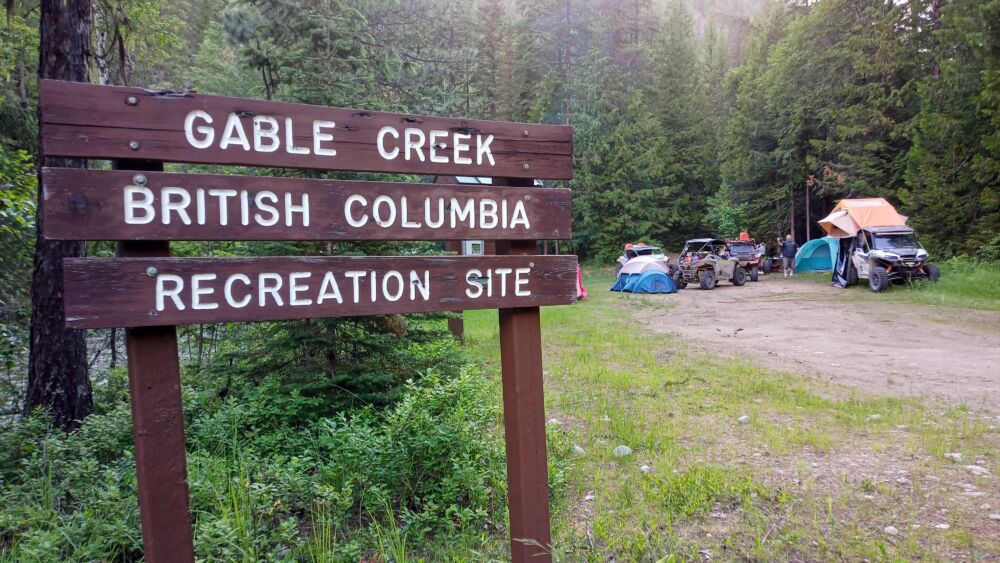
The afternoon portion of the ride took the group down to the Christian Valley where we had approximately 5km of pavement riding before getting back on the FSR that went up, down, up and down again before arriving at Gable Creek Recreation Site, a beautiful campsite at the confluence of Gable Creek and Granby River.
Riders quickly converted into campers, setting up their tents, getting the campfire going and supper underway. While sitting around the evening campfire we watched two bears cross the bridge over the Granby River then disappear into the forest opposite our campsite.
After approximately 275km of riding sleep came quickly with the cool breeze and soothing stream sounds providing the perfect antidote even for seasoned insomniacs.
A group of riders from the Grand Forks ATV Club stopped at the rec site just as we were heading out Saturday morning, they were on the annual ride on a favourite trail and shared their knowledge of the area.
The first objective was Renata on the shores of Arrow Lake and we were all smiling ear to ear after enjoying the absolutely amazing trails maintained by the Grand Forks ATV Club. Renata is a slight departure from the shortest route to Edgewood but the view from the beach makes you want to plunk down in the sand and enjoy a sunny afternoon.
Knowing that we still had nearly 300km of riding ahead we headed back out on the FSR. Burnt trees from the previous years forest fires lined the roads most of the way to Edgewood. It’s possible to make good time on the wide and well maintained FSRs in this area but you also have to keep it somewhat in check because going off the road would send you a long, long way down the steep hillside.
We arrived in Edgewood in the early afternoon and headed straight to the Edgewood General Store to line up at the fuel pumps and grab some lunch then stopped at a roadside ice cream truck before heading back onto the trails.
This section of the trail from Edgewood to Kettle Valley had a big question mark on it because we’ve been told a trail exists but that it was steep and narrow. It turns out it is passable by 64″ side x sides (even with cargo racks and rooftop tents) and we found the steep section which is a 20′ slippery rock face which was a reasonably easy climb in a side x side but most will want to winch up on a quad.
Once back out of the tight forest and incessant buzzing of mosquitoes, the group started making miles on the higher elevation FSRs near Mt Scaia and Lightning Peak. A refreshing break was taken at the Kettle River Recreation Site before the final blast along Harris Creek FSR then a mix of our regular trails on the Aberdeen Plateau to finish up back to the King Eddy staging area at 9:00pm.
The ride was approximately 600km in length and forms one possible backbone that can provide a nearly unlimited number of jumping off points for side trips to lakes, mountain vistas, recreation sites and access into other communities.
600km is a fair amount of ground to cover in two days but can be done by maintaining 80kmh where possible on the FSR. This loop could easily be turned into a three to seven/ten/fourteen? day trip by exploring more side trails, stopping more often and basing your camp at one of the countless recreation sites for further exploration of an area.
We found our machines could go further on fuel than we gave them credit for but it’s nice having the option of accessing fuel in Beaverdell and Edgewood. We definitely recommend bringing extra fuel equal to what your fuel tank holds (40L for side x sides and 20L for quads) so you have the flexibility to explore further.
Beaverdell and Edgewood are open to ATVs riding into town to access services provided you ride responsibly and with respect or we all could lose access.
The route was developed on GaiaGPS using a combination of satellite and road layers vetted by reviewing public tracks shared by other users. Now that we’ve ridden the route there are a few modifications we’ll make for future trips, partially to simplify or improve the route but also to take in new sections of trail and see different areas.