During the 2021 season we’ll post the GPS coordinates of secret locations throughout the region.
Find the secret spot, take a selfie identifying the secret location and send it to info@vernonatvclub.ca to be entered to win. The secret spot will be something obvious at those coordinates so look around and take a selfie with what you think is the secret spot.
Motorized vehicles yield to cyclists, pedestrians and horses
A little courtesy goes along way to protecting access to trails and fostering relations with other trail users.
Many cyclists, pedestrians and horseback riders will move off the trail when they hear an ATV coming but this doesn’t mean you should continue past them. Proper trail etiquette calls for the ATV rider to pull to the side of the trail, shut their engine off, remove their helmet (if horses present) and allow the other trail users to pass.
Use Extra Caution Around Horses
Horses can be unpredictable and spook when scared, please use extra caution around horses for everyone’s safety:
Pull to the side of the trail far enough for horses to pass safely as soon as you see them.
Pull to the downhill side of the trail if possible since horses tend to perceive unknown threats on the uphill side as predators.
Shut off your motor as soon as possible and remove your helmet. The horse will be more likely to recognize you as a human.
Speak to the rider and horse in a friendly, relaxed tone.
When approaching horses from behind, stop, call ahead and make yourself known to the rider. Ask them if it is OK to pass and the best way to do so.
Horsemen may pull to the side of the trail a safe distance if they hear an OHV approaching, but this does not necessarily mean it is safe for you to ride by. Stop and wait for instructions from the horseman.
Ask the horseman how he/she would like to proceed.
The horseman will know his/her horse and how the horse reacts to other trail enthusiasts. The horseman may ask you to stay put and ride past you.
The horseman may ride to the side of the trail and ask you to ride or push past them.
If you ride by a horse, keep your rpm’s low and steady and your sound as low as possible.
Sudden movements or sounds can startle horses.
Be alert, aware and on guard for oncoming traffic.
Saturday June 19 – 5:30pm Start @ King Edward Staging
An annual favourite where riders hit the trails for an evening ride to take in the longest daylight hours of the year without needing headlights. BRING BUG SPRAY!!!
The ride kicks off at 5:30pm sharp with a safety meeting then gets rolling on the trails. It’s King Eddy so we’ve ridden here a bunch but we’ll try to incorporate some new trails that most haven’t ridden while still taking in the communication tower lookout over Kalamalka Lake and the North Okanagan valley. The ride will be a mixture of Forest Service Road and old roads that now look and feel like trails.
Start Time: 5:30pm sharp Safety Meeting End Time: approximately 9:30pm Ride Length: up to 80km, a single tank of fuel in your machine should suffice Ride Difficulty: Beginner to Intermediate trails with other members assisting at difficult obstacles if needed Ride Speed: up to 60kmh on Forest Service Road sections Number of Breaks: 1 longer break at the lookout, other short stoppages Bathroom Facilities: we will pass numerous rec sites with outhouse facilities throughout the ride Machine Size: machines up to mid-60 inch size should fit on the trails.
Parking is available along the Forest Service Road immediately after turning off Highway 6 in the Coldstream.
Everyone is welcome, the Vernon ATV Club encourages quad and side x side riders to attend up to 3 rides to meet other riders, find new trails and get a sense of what the club is all about. We’re sure you’ll like the club and want to join!
We’re back to hosting group rides but we must continue being COVID responsible citizens. Riders must maintain physical distance of 6′ or more from other riders not in their bubble and wear masks any times you may be in close proximity of other riders.
The ride will start from the Deep Creek Road staging area after a safety meeting at 10:00am sharp!
If you’re coming from Vernon there will be a convoy leaving the Tim Horton’s parking lot on 53rd Avenue (across from Walmart) at 8:45am.
Start Time: 10:00am Safety Meeting End Time: approximately 4:00pm Ride Length: up to 80km, a single tank of fuel in your machine should suffice Ride Difficulty: Beginner to Intermediate trails with other members assisting at difficult obstacles if needed Ride Speed: up to 60kmh on Forest Service Road sections Number of Breaks: 3 planned breaks at 10:30am check-in, 12:30 lunch break and afternoon snack break Bathroom Facilities: we will stop at Silver Creek Community Park after lunch where there are toilets, we are unsure if they are open with current COVID restrictions. Machine Size: machines up to mid-60 inch size should fit on the trails. If you ride a wider machine you should come prepared to do some trimming, just in case.
Our first ride back as a group since the fall of 2020. The ride will proceed at a safe trail speed and as fast as 60kmh on Forest Service Road sections. Trail conditions vary from Forest Service Roads to old and deactivated roads that have grown in over the years to now become narrower trails.
There will be a 1/2 hour lunch break (free BBQ for members, $5 for friends and guests) and a couple of other short stops to enjoy numerous viewpoints.
We will be using the leapfrog method of marking corners where the leader instructs a rider to park at a corner to indicate the way then that rider joins back on in front of the tailgunner.
A little (or a lot) of rain has never stopped a Vernon club ride so come prepared for all conditions.
Everyone is welcome, the Vernon ATV Club encourages quad and side x side riders to attend up to 3 rides to meet other riders, find new trails and get a sense of what the club is all about. We’re sure you’ll like the club and want to join!
We continue our series on trail navigation and ride planning tools with a look at creating routes and finding public tracks to keep on the plotted course.
Option 1 – Create a Routes In GPS terminology a route is series of waypoints that when followed using your GPS guides you along the intended direction of travel. Most/all GPS apps and devices allow route creation so when riding you follow a coloured line along your predetermined set of directions rather than having to stop at each corner to check the map.
Option 2 – Find Public Tracks If you prefer to follow a track saved by another rider, many of the online GPS services allow you to search existing trails then save or sync to your device.
The existence of a track doesn’t mean you are allowed to or should ride that trail.
Following a track may take you across private land, sensitive terrain, areas closed to ATVs or on difficult trails. Always research where you are riding and be prepared to turn back!
BRMB Web Map with inset of iPhone 7 Map Tools screen. I wasn’t able to find a way to plan a route on the Web Map and transfer it to the App, nor plan on the App.
The BRMB Web Map lets you search “Adventures”, here King Eddy ATV Trails are shown and can be added to a trip or downloaded in GPX or KML format.
Backroad Mapbooks We ruled out using the paper Backroad Mapbooks for detailed ATV ride planning last week so we’re only looking at the GPS Maps and Web Map/App options this week from BRMB.
GPS Maps Every Garmin GPS made since the dawn of time has had Route creation hiding in the menu and the Backroad Mapbooks layers provide additional data on both your handheld GPS and in Basecamp when your GPS is connected to the computer. See the Garmin section below for more information on Route creation.
BRMB Web Map & App Using a PRO account on the BRMB Web Map it’s possible to “Draw a Line” to create a route to follow later, this is then saved and available for download as a GPX or KML file.
Two problems I encountered: a. I couldn’t find a way of importing or opening this route on the BRMB App on my phone.
b. There is no way of “Drawing a Line” on the BRMB App which means route planning via the app is currently not an option.BRMB is pouring a lot of effort into the BRMB Web Map and App so I won’t be surprised to see many more features arriving in the coming months. BRMB is offering a 3 month free PRO trail to ATVBC members, to get your 3 month trial contact ATVBC by email.
To access Public Tracks shared by Gaia GPS users, enable the Public Track Map Overlay.
Public Tracks appear as faint green lines on the map, click a track for more info and to save to your account.
Gaia GPS Using a Free or Premium account at Gaia GPS lets you browse Public Tracks shared by others and create your own Routes. Looking at Tracks shared by others is a great way to explore new areas and fill in gaps in your trail database.
It’s also possible to create Routes which are saved in your account and instantly available for use on other devices signed in to your Gaia GPS account.
Using Backroad Mapbooks and Gaia Topo map layers to quickly plan routes on your computer, tablet or smart phone.
Garmin Basecamp route creation and inset of Garmin GPS screen with Routes highlighted.
Garmin Route creation has always been an important feature in Garmin devices and Basecamp. A route can be created directly on your handheld GPS through the Routes menu or in Basecamp by clicking the Create a Route button under Creation Tools at the top of the screen. Once created in Basecamp the file must be sent to your handheld GPS for use.
As we saw last week, the amount of information available via Basecamp is dependent on having Garmin BirdsEye, Topo or Backroad Mapbooks data otherwise the default beige screen provides no navigational assistance.
Search the map for trails shared by other riders, the left sidebar shows ride data, photos and links to a full description and download options.
Wikiloc One of the main benefits of community contributed content is the ability to see, download and use files added by fellow riders. It’s also possible to create a route on the webmap by using the “Draw your trail by hand” feature found under the Upload Trails option.
The trail detail page has a detailed description of the ride, photos, a list of waypoints and trails in the vicinity and download options ranging from transfer to the Wikiloc App, GPX, Garmin, Suunto and more.
Stay Tuned! Next week we take public tracks or Routes we’ve created and load them onto our chosen chosen GPS device/app so you can navigate the intended route.
It takes years of experience to become a grizzled veteran trail rider that remembers all the roads, trails and intersections. A well kept secret of grizzled veteran trail riders is they are usually exceptionally good at using a GPS to track rides and have an abundance of previous ride tracks at hand when riding in the area again.
Exploring with no plan can be hugely rewarding and take you places most have never been, but it can also be fruitless and result and hours wandering forest service roads that dead end in cut blocks. Knowing how to find where trails are and then navigate those trails while riding can up your game from group ride follower to intrepid backcountry explorer.
Navigating new trails and riding areas can be broken into three steps:
Ride Planning – how to find trails
Ride Navigation – staying on the plotted course
Ride Tracking – saving your track for future use
This week’s email starts with a look at Ride Planning tools. Check in over the next couple of weeks for parts 2 & 3 covering Ride Navigation and Ride Tracking.
Part 1 – Ride Planning Until you’ve built a database of trails you’re either going to do a lot of riding to find trails or you can access trails shared or published by others.
Even just a few years ago your options were basically limited to purchasing a chip for your GPS which provided a layer showing roads and trails. With the explosion of online services and apps these same trails can are available from a variety of sources with most offering free access to a limited feature set with premium paid options and in app purchases.
Myra-Bellevue Provincial Park, Page 10 Thompson Okanagan Backroad Mapbook
Duffy-Greenstone Trails – MicroSD Card BC GPS Maps for Garmin
Backroad Mapbooks The homegrown success story, BRMB is based in BC and has been a popular option for ATV riders looking for trails for years. You’ve probably seen and/or used their paper mapbooks found in convenience stores, purchased a GPS chip for your Garmin or more recently accessed their information via smartphone GPS apps.
Paper Mapbooks – $29.95 + up The 5th edition of the Thompson Okanagan Backroad Mapbook provides 51 maps at 1:200,000 scale covering the region. A good backup if your GPS quits and an effective tool for overall route planning but often not enough detail for ATV level route planning.
Also available as an ePUB or PDF file for use on your favourite smartphone, tablet or eReader. Note the ePUB/PDF is not georeferenced meaning you don’t know your position on the map.
GPS Maps – $69.95 + up The 2020 version of Backroad GPS Maps for BC provides province wide coverage to a 1:20,000 scale. Much more than just ATV roads and trails, other information types include: lake/river/stream data, private land, wildlife management units for hunters, oil and gas location data, railway corridor markers, searchable points of interest and trails for all types of recreation users.
Compatible with Garmin Basecamp when connected to your GPS device with the SD card installed for trip planning on your Mac or Windows computer.
The Free BRMB Web Map is effectively useless for planning, all options/features prompt to sign up for a PRO (paid) account.
The BRMB Web Map is chockablock with data, features and resources when accessed with a PRO account.
Once logged in at the PRO account level the features spill forth from all sides. Satellite and Topo maps are available, Backroad, Fishing, Hunting, Paddling, Park, Recsite, Trail, ATV, Snowmobile, Wildlife and Winter Adventure buckets contain numerous options that can be toggled on the map.
Access the Web Map on your computer or tablet or download the app to your Android or Apple smartphone.
Pricing is listed below or visit the BRMB website:
Free – unlimited basic platform access
$3.50/month – month to month access to the PRO platform
$35.00/year – year round PRO platform access
$90.00/3 years – 3 year subscription to PRO platform
Use Gaia GPS on your computer, tablet or smartphone to find trails shared by others or create your own routes on the map using the planning tools then follow them on your smartphone for navigation.
Gaia GPS A webmap and app for all types of recreational activities, Gaia GPS has undergone extensive updates to both the website and the Android and Apple apps in the 5 years I’ve been subscribed.
After purchasing an iPhone 7 Plus in 2016 I decided to make the move away from traditional GPS devices to using a smartphone GPS app. After testing 10+ apps that were available then, Gaia was my winner based on cost and features. Each year I review competitors and I still haven’t found a better GPS app for my purposes.
Use the webmap on your computer or tablet for planning rides. A free account is required to access the map, this limits you to basic map layers but gives the ability to view and save tracks shared by others.
Being able to search and save tracks shared by others means a nearly unlimited number of trails at your disposal.
Without TOPO Maps and BirdsEye imagery Basecamp leaves something to be desired for ride planning.
Garmin The dominant player in the consumer GPS market, Garmin leads the way in dedicated handheld and dash mounted GPS products for ATVs.
On the ride planning side BirdsEye and TOPO maps can be purchased to add details to your GPS device and will load onto Gamin Basecamp when your GPS is connected to your computer. Without BirdsEye and TOPO Maps Basecamp doesn’t provide much information to do ride planning.
Basecamp is used to download tracks and send routes/waypoints to your GPS.
Garmin doesn’t currently have an online webmap or shared community trails database that I’m aware of.
A free Wikiloc account lets you filter by activity type, search by trail name, find trails on a map and download GPX files shared by others with a paid option for Premium features.
Wikiloc Wikiloc is another excellent online community style webmap and app for all types of recreational activities.
A free Wikiloc account lets you search trails by name, activity type or location on the world map, download trails shared by others (tracks are simplified to 500 points for free accounts) track rides and upload your trails. It is possible to create a route on the webmap by using the “Draw your trail by hand” feature found under the Upload Trails option.
Download the Android and Apple apps to try Wikiloc for your next ride.
And all the others? Oh ya, there are too many other options to list so we’ve stuck to the most popular tools used by ATVers for GPS navigation apps and planning tools. Let us know what you use so we can compare and share with others.
Stay Tuned! Next week we will look at how to download tracks or create routes and transferring them to your chosen GPS device/app so you can navigate the intended route.
Safety is one of the key drivers of the ATV Club. We all share a love of the backcountry and want to ensure everyone makes it home safely after every ride.
This past weekend a Saturday evening ride started out perfectly with the small group enjoying the clear skies and warm evening temperatures. As the ride ventured up Bardolph Road it turned onto an old logging road that was new to the group. It was a postcard trail, the old roadbed was smooth and in great condition and followed a creek draw at a moderate incline through the cedar forest.
Enjoyment quickly turned to apprehension however because shortly after crossing the creek the trail narrowed and became steep and rutted. This section of trail was still passable though which encouraged riders to continue up the steep slope. The point of no return appeared after riders committed to continue upslope where a large exposed tree root created a 12″ vertical ledge on the already steep trail.
The side x sides and 2 up quads cautiously navigated the vertical ledge but the front end on single seater quad wouldn’t stay down without help from other riders in the group. This group was fortunate because the other riders were experienced, spotted the hazard and held the single seater quad to prevent it from flipping backward down the hill.
Inexperienced riders or someone riding by themselves would have been forced to make a split-second decision to try climbing the ledge or get stopped on the steep incline then somehow back down.
Identifying & Reporting Hazards In the example above the ATV Club is going to place a sign warning riders of the steep hillclimb ahead so they have the opportunity to turn around in a safe area rather than being stuck in a dangerous situation on the steep hillside.
We want your assistance identifying potentially dangerous trails and hazards so they can be assessed and mitigated through signage, trail work and education.
Please share what you see while out riding by taking photos and providing a description of the location or send a GPS waypoint (if possible) to the Vernon ATV Club by email info@vernonatvclub.ca, via our website or Facebook.
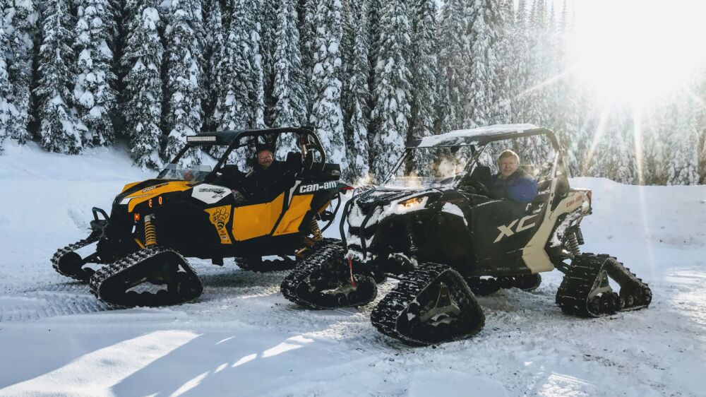
A handful of Vernon ATV Club members have tracks on their quad or side x side, if you’re on the ATV Trail Riders Group you’ve seen photos and stories throughout the winter.
Inevitably the tracked rider ends up doing tow truck duty at various times when wheeled machines find the limits of how far they can go in the fluffy stuff.
Rescuing wheeled ATVers in the winter is only part of the gig, what are some of the pros and cons of ATV tracks?
Pros
Turns your quad, side x side or dirtbike into a 4 season toy.
You only need to maintain/store/accessorize/insure 1 vehicle.
Tracks are less expensive and more reliable than many (most?) similarly priced sleds.
Gets you out on the mountains to be above the low valley cloud so common through Okanagan winters.
Cons
New tracks range in price from $3500-8500 so they’re definitely not cheap but you can often find deals on lightly used track kits in the classifieds.
Not terribly fast and not for steep slopes, you’ll never beat a sled here.
If you get a track machine stuck you’ve discovered what a 2000lb anchor looks like.
Rough riding on hardpacked surfaces.
Tracks gear your machine down and pushing through snow creates a lot of resistance so you’ll use 25-50% more fuel to go the same distance.
Get in touch with the club by email if you have questions about tracks and watch upcoming emails for more stories about tracks before they’re safely stored away for the summer.
With thoughts turning to the trails we see a surge in new and renewing memberships at this time of the year. It’s time to park the sled, skis or snowboard and what better way to avoid yardwork than heading out riding with your ATV buddies.
If you’re new to ATVing or the area you’ve found the right club. Our members love riding, sharing their favourite trails, and protecting the backcountry we all enjoy so much. As soon as this COVID thing is figured out we’ll be back to hosting regular club rides too.
You can keep up with the club through these weekly emails, look back through past articles on our website at www.vernonatvclub.ca, or our Facebook Page.
We also encourage you to join the Vernon ATV Trail Riders Facebook Group where you’ll find people interested in riding, get answers to questions and see photos and ride stories.
If you have any questions get in touch with the club by email info@vernonatvclub.ca.
Welcome to the club, we’ll see you on the trails soon!
Warm weather continues to push the snow back on the trails enough to start getting back on 4 wheels.
A recent trip to Postill Lake rewarded with some open technical trails lower on the mountain and well traveled snow trails at higher elevations. The snow softened quickly in the afternoon so if you’re out riding this weekend remember to ride with some buddies while maintaining your safe COVID distance.
Think Safety Our riders have an excellent safety record so keep up the great work and safe riding. Remember at this time of year morning conditions are usually icy and afternoon conditions leave machines high centred miles deep in the back country.